
The Prophecies Of Ghana-Ivorian Dispute
…International Maritime Law in Context- Equidistance, Relevant Circumstances and the “Disproportionality test” Examined
BRIEFS & COMMENTARY (PART II of II)
Learned Principal, in our earlier dispatch- “The Promises of Ghana-Ivorian Maritime Rifts”, we refreshed your memories on the historic but competing legal schools of thought on the LOS. We respectfully, focused your attention on the more recent delimitation maritime case involving Bangladesh and Myanmar. The rule in Articles 74 and 83 of the 1982 LOS Convention is that the delimitation of the exclusive economic zone/continental shelf with the opposite or adjacent coasts shell be effected by agreement on the basis of international law, as referred to in Art 38 of the Statute of the ICJ. The general principle puts emphasis on a State obligation to negotiate in good faith with a view to strike agreement. In absence of this, and unless another boundary line is justified by special circumstances, the boundary shall be determined by application of the principle of equidistance/median line from the nearest points of the baselines from which the breadth of the territorial sea of each State is measured. [9] This combined rule consisted of two substantive elements, equidistance and special circumstances. For this discussion, the Conference finally adopted the 1958 Geneva Conventions relating to respective maritime zones. [10]
Int.’Law in Context
The Sea-Bed Committee established by the General Assembly in 1968, to consider a preparatory committee for the new law of the sea, could not complete its preparatory work, so in December 1973, UNCLOS III was convened. It is found that the contradiction between the so-called pro-equidistance States and States favouring a concept of equity seriously hampered the negotiations and became a hard issue on the agenda of UNCLOS III. During the conference, the proponents of the equidistance line (for example: Denmark, Norway, United Kingdom, Canada, Greece, Italy, Japan) favoured the treatment of the equidistance/median line as a standard of delimitation. They insisted that it was the principle of international law governing delimitation cases, relying on Article 6 of the 1958 Convention on the Continental Shelf. They considered that the equitable principle standard was vague and subjective. Supporters of the equitable approach (for example: France, Turkey, Ireland, Kenya, Liberia, Libyan Arab Jamahiriya, Poland, Romania) objected to the very mention of the equidistance/median line as a standard for delimitation and rejected the elevation of that standard to the status of a basic principle. [11]
They relied on the decision of the first case brought before ICJ [the 1969 North Sea Continental shelf case- Federal Republic of Germany/Denmark; Federal Republic of Germany/Netherlands).], where the ICJ minimised the importance of the median/equidistance line of article 6 of the 1958 Continental Shelf Convention, and emphasized the equitable principle as customary international law on delimitation. Through this case, equidistance rule, ceased to be a principle and became merely one method among others. But the Court commented that it “has never been doubted that [this] method of delimitation is a very convenient one”and that “it would probably be true to say that no other method of delimitation has the same combination of practical convenience and certainty of application.” In these Briefs, we attempt to consider in abstract, the rulings/commentaries on the following cases: Bay of Bengal; the USA and Canada; Guinea/Guinea-Bissau; and not least, the Cameroon/Nigeria Case. India Case not considered.
CASE STUDY
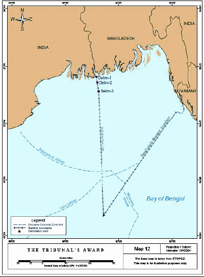 After years of negotiations and despite many no final delimitation agreement was agreement over their maritime boundary in the Bay of Bengal, the ITLOS, on 14 March 2012, issued its judgment in the dispute between Bangladesh and Myanmar- both parties to UNCLOS, in the Bay of Bengal. Relations became strained in October 2008 when survey ships subcontracted by Daewoo, and acting under licence from Myanmar, began conducting survey work close to St Martin’s Island and in a maritime area claimed by Bangladesh. In that case, Bangladesh responded by dispatching three naval vessels leading to a stand-off between the two navies lasting over a week until the Daewoo vessels withdrew [2]. Without much time to spend on the case history let us consider what had been told about this landmark decision:
It strengthens the three-stage delimitation method expounded in the Black Sea case; It began a new chapter in the law on maritime boundary delimitations by delimiting the Outer Continental Shelf’ (OCS); It reinforced the notion that in law there is only a single continental shelf and that there is no difference in the application of Law on Sea Convention (LOSC) Article 83 within or beyond 200 nm; and that the delimitation of the OCS and the delineation of its outer limits are separate procedures. This involves three separate stages:- First, drawing a provisional equidistance line based on the geography of the States’ coasts; and Second, asking whether there were any “relevant circumstances” which required that line to be adjusted to allow for an equitable result; and finally, applying the “test of disproportionality“. After constructing the provisional equidistance line, Bangladesh’s “manifestly concave” coast line was a “relevant circumstance” which necessitated adjustment of that provisional equidistance line. [12]
Concavity will not always be taken into consideration, but “…when an equidistance line drawn between two States produces a cut-off effect on the maritime entitlement of one of those States, as a result of the coast, then an adjustment of that line may be necessary in order to reach an equitable result.” [2] However, it did not consider that St Martin’s Island, a “significant maritime feature by virtue of its size and population and the extent of economic and other activities“, which the ITLOS had awarded its own 12 NM territorial sea, warranted an adjustment of the provisional equidistance line; nor would the Bengal depositional system, being the “physical, geological and geomorphological connection between Bangladesh’s land mass and Bay of Bengal” be a relevant circumstance to be taken into consideration either. The ITLOS then endorsed the third stage in the methodology for maritime delimitation. At this third stage, a tribunal must ascertain whether the delimitation line leads to “an inequitable result by reason of any marked disproportion” between the ratio of the relevant coastal lengths and the maritime areas of the respective States parties. This tends to be a fairly general test that one side has not been treated inequitably, rather than a substantive analysis of whether a ratio is “proportionate“.
The ITLOS has noted that, “mathematical precision is not required“. After deciding that the scientific evidence presented by Bangladesh did not prevent Myanmar making a claim to the outer part of the continental shelf, the ITLOS found that no further adjustment to the equidistance line was necessary: the ratio between the total areas awarded and the ratio of the respective lengths of Bangladesh and Myanmar’s coastlines were not disproportionate. It is suggested that the ITLOS’s judgment helps to clarify some of the issues at stake including the sovereign rights of a large area of the EEZ and continental shelf of the Bay of Bengal. These are directly relevant to the rights of Bangladesh and Myanmar to grant hydrocarbon exploration and production rights in those areas and will give comfort to oil companies such as ConocoPhillips, Tullow and Daewoo who have interests there. [2]
Yet for all the clarity of the judgment, Herbert Smith Freehills Arbitration argues, uncertainties remain: First, a small “grey area” within 200 NM of the Myanmar coast, but on the Bangladesh side of the delimitation line, was not delimited by the ITLOS. Thus “after considering the difficulties it presented, the ITLOS instead noted that there existed many ways for the parties to reach an agreement on this limited area, hinting perhaps at joint development or unitisation. Second, the adjusted equidistance line extending beyond 200 NM plotted by the ITLOS does not have a terminus point – it is said to continue “until it reaches the area where the rights of third party States may be affected.” That those rights remain a live issue and that the status of India’s substantial claims within the Bay of Bengal remains very much unsettled. As noted by the ITLOS, its judgment does not bind third-parties such as India (which is currently engaged in arbitral proceedings of its own with Bangladesh) and its delimitation is without prejudice to the delineation of the continental shelf to be decided upon by the CLCS. [2]
The Prophecies of Ghana?
The Prophecies Of Ghana-Ivorian Dispute
In 2002, the ICJ gave judgment on the maritime boundary between two adjacent States- Cameroon and Nigeria. [13] The States asked the Court to draw a single maritime boundary for each respective zone. The parties also agreed upon the method of delimitation: to draw an equidistance line and then consider whether there are factors calling for adjustment of that line to achieve an equitable result. [Ibid. P. 4.] But the States disagreed about the existence of special circumstances necessary for the shifting of equidistance line. Relying on its earlier authorities judgment, the Court “made it clear what are the applicable criteria, principles and rules of delimitation” for a single maritime boundary which “are expressed in the equitable principle/relevant circumstances method […] which is very similar to the equidistance/special circumstances method applicable in delimitation of the territorial sea.” [Ibid. Par. 88.] Beyond the territorial sea, the Court referred to the case between Qatar and Bahrain, [14] where it had stated that […] for the delimitation of maritime zones beyond the 12 mile zone it would first provisionally draw an equidistance line and then consider whether there were circumstances which must lead to an adjustment of that line. The Court found it convenient in applying that rule. [Ibid, 14, Par.289]
For the delimitation of the territorial Sea the Court considered that there existed a valid international agreement between the States, [Ibid. Par. 263] – leaving it with the delimitation of the EEZ and CS of the respective States. Before drawing the equidistance line, the Court found it crucial to define the relevant coastlines and the location of the base points for the construction of that line. [Ibid. Par. 290-292] It looked first for the existence of geographical circumstances- rejecting Cameroon’s position regarding the concavity of its coastline as a special circumstance for the modification of the equidistance line as relevant coastlines for the delimitation already determined by the Court. It noted: “sectors of coastline relevant to the present delimitation exhibit no particular concavity” [Ibid. 14, Par. 297], as the concave sector of Cameroon’s coast was outside the delimitation area.” The Court did not also regard the presence of the Bioko islands as a circumstance justifying the shifting of the equidistance line, stating the island did not belong to either of the States party to the dispute. [Ibid. Par. 299]
In 1984, an ICJ Chamber was requested by two adjacent States, the USA and Canada, to draw a single maritime boundary in the Gulf of Maine for both the continental shelf and fishery zones. [15] The Chamber was confronted with the following: “what is the course of the single maritime boundary that divided the continental shelf and fisheries zone between the respective States.” [16] In its submission, Canada invoked the application of the equidistance line based on Article 6 of the 1958 Convention on the Continental Shelf, which was in force for both States. Canada submitted that equidistance/special circumstances method should be applied as a treaty rule for the CS and as a general norm for the delimitation of the adjacent fishery zone. The Chamber said as treaty law for the CS this principle could be valid, but to accept the latter […] would amount to transforming the combined equidistance/special circumstances rule into a rule of general international law, and thus on capable of numerous application, whereas there is no trace in international custom of such transformation having occurred. [17]
The Chamber also pointed out that equidistance […] cannot have such mandatory force even between States which are parties to the convention, as regards to a maritime boundary concerning a much wider-subject than the continental shelf alone. [Ibid. Par. 124.] The Chamber also took into account the view expressed in the 1969 North Sea case, that equidistance was not a principle of customary international law (see, the 1982 Tunisia/Libya case and the two adjacent States Case of Guinea and Guinea-Bissau, 18 February 1983), where whether the Convention of 12 May 1886 between France and Portugal and the protocols annexed to that Convention established the maritime boundary between the respective States and in which Guinea-Bissau raised equidistance, might be relevant. It argued that the coast of the two States are opposite and the preference for equidistance was found in the argument that equidistance faithfully reflects the coastal configuration and complies with the requirements of the equitable principle not to refashion nature. It also acknowledged that the existence of special circumstances might lead to an adjustment of the provisional equidistance line. [18]
The Tribunal itself considers that the equidistance method is just one among many and there is no obligation to use it or give it priority, even though it is recognised as having a certain intrinsic value because of its scientific character and the relative easy with which it can be apply. After carefully examining the general direction and configuration of the coastline, the Tribunal observed the existence of special circumstances, such as the concave coasts of the States, if taken the whole configuration of the West African coast and the presence of some islands. Taking into account these circumstances and the situations of adjacency, it rejected to apply the equidistance method, as it would yield an inequitable result. [18] In 2002, the ICJ gave judgment on the maritime boundary between two adjacent States of Cameroon and Nigeria. Applying the Guinea-Bissau reasoning the Court said that “[…] for the delimitation of maritime zones beyond the 12 mile zone it would first provisionally draw an equidistance line and then consider whether there were circumstances which must lead to an adjustment of that line.” [19] For the delimitation of the territorial sea, the Court found valid international agreement between the States- leaving it with the delimitation of the EEZ and CS of the States Parties.
CONCLUSION
So what could be the prophecies of this “go-to-court-go-to-court Ghana-Ivorian Rifts be? In this article, we have sought to consider the following: (a) Geology and geomorphology; (b) Socio-economic circumstances; (c) Conduct of the States; (d) The interest of third States and security (political) consideration; and (e) Historic title. It also acknowledged that the existence of special circumstances might lead to an adjustment of the provisional equidistance line. But empirical case studies also illustrate that after carefully examining the general direction and configuration of the coastline, a tribunal might acknowledge the existence of special circumstances, such as the concave coasts of the States, if taken the whole configuration of the West African coast and the presence of some islands. The promises or the prophecies are that taking into account these circumstances and the situations of adjacency, a Maritime Special Court had also rejected to apply the equidistance method, as it could yield an inequitable result.

The Prophecies Of Ghana-Ivorian Dispute
Asante Fordjour LLB (Hons) LLM Int’Law And Criminal Justice, authored this article.
JusticeGhana
………….
References
[1] UNCLOS, http://www.un.org/depts/los/clcs_new/continental_shelf_description.htm)[2] Herbert Smith Freehills Arbitration, “International Tribunal for the Law of the Sea issues judgment in Bangladesh/Myanmar (26 March, 2012) , http://hsfnotes.com/arbitration/2012/03/26/international-tribunal-for-the-law-of-the-sea-issues-judgment-in-bangladeshmyanmar, date accessed, 02 May 2015
[3] Am Internationalen Seegerichtshof 1, Press Release, DISPUTE CONCERNING DELIMITATION OF THE MARITIME BOUNDARY BETWEEN GHANA AND CÔTE D’IVOIRE IN THE ATLANTIC OCEAN (GHANA/CÔTE D’IVOIRE)
ITLOS/Press 229, 25 April 2015
[4] Myjoyonline, “Ghana won’t negotiate with Ivory Coast”, http://www.myjoyonline.com/news/2015/May-2nd/ghana-wont-negotiate-with-ivory-coast.php#sthash.4mRe2FuC.LtsqOAEQ.dpuf, date accessed, 02 May 2015
[6] Nugzar Dundua(2006-2007), “Delimitation of maritime boundaries between adjacent States”
http://www.un.org/depts/los/nippon/unnff_programme_home/fellows_pages/fellows_papers/dundua_0607_georgia.pdf, date accessed, 06 May 2015
[7] Alexander L. M. The delimitation of maritime boundaries. Political geography quarterly 5, 1986. PP. 1-2.; (Ibid, 6)
[8] Prescott V and Schofield C. The maritime political boundaries of the world . 2005. P. 216.
[9] Article 6 of the Convention on the Continental Shelf. Done at Geneva, on 29 April, 1958
[10] Convention on the Territorial Sea and Contiguous Zone. Done at Geneva, on 29 April, 1958.
[11] Adede. A.O. Toward the formulation of the rule of delimitation of sea boundaries between states with adjacent or opposite coasts. Virginia journal of international law 19, 1979. P. 214,( cited in Nugzar Dundua(2006-2007), Ibid 6)
[12] Bjarni Már Magnússon, “Current Legal Developments International Tribunal for the Law of the Sea, Judgement in the Dispute concerning Delimitation of the Maritime Boundary between Bangladesh and Myanmar in the Bay of Bengal (14 March 2012) http://www.academia.edu/6307074/Judgement_in_the_Dispute_concerning_Delimitation_of_the_Maritime_Boundary_between_Bangladesh_and_Myanmar_in_the_Bay_of_Bengal, date accessed, 02 May 2015
[13] Land and Maritime boundary between Cameroon and Nigeria (Cameroon v. Nigeria; equatorial Guinea intervening). Judgment of 10 October 2002-Merits. Hereafter: 2002 Cameroon/Nigeria Case.
[14] Maritime delimitation and territorial questions between Qatar and Bahrain (Qatar v. Bahrain).
Judgment of March 2001 – Merits. Hereafter: 2001Qatar/Bahrain case.
[15] Case concerning delimitation of the maritime boundary in the Gulf of Maine area (Canada/United States of America). 12 October, 1984. Hereafter: 1984 Gulf of Maine Case.
[16] 1984 Gulf of Maine case. Article II of the special agreement. P. 253.] [17] Jagota S.P. Op. cit. P. 307. Also see: 1984 Gulf of Maine case. Par. 122.] [18] Award of 14 February, 1985 arbitration for the delimitation of the maritime boundary between Guinea and Guinea Bissau. Hereafter: 1985 Guinea/Guinea-Bissau Case
[19] Land and Maritime boundary between Cameroon and Nigeria (Cameroon v. Nigeria; equatorial Guinea intervening). Judgment of 10 October 2002-Merits. Hereafter: 2002 Cameroon/Nigeria Case., Par. 289.